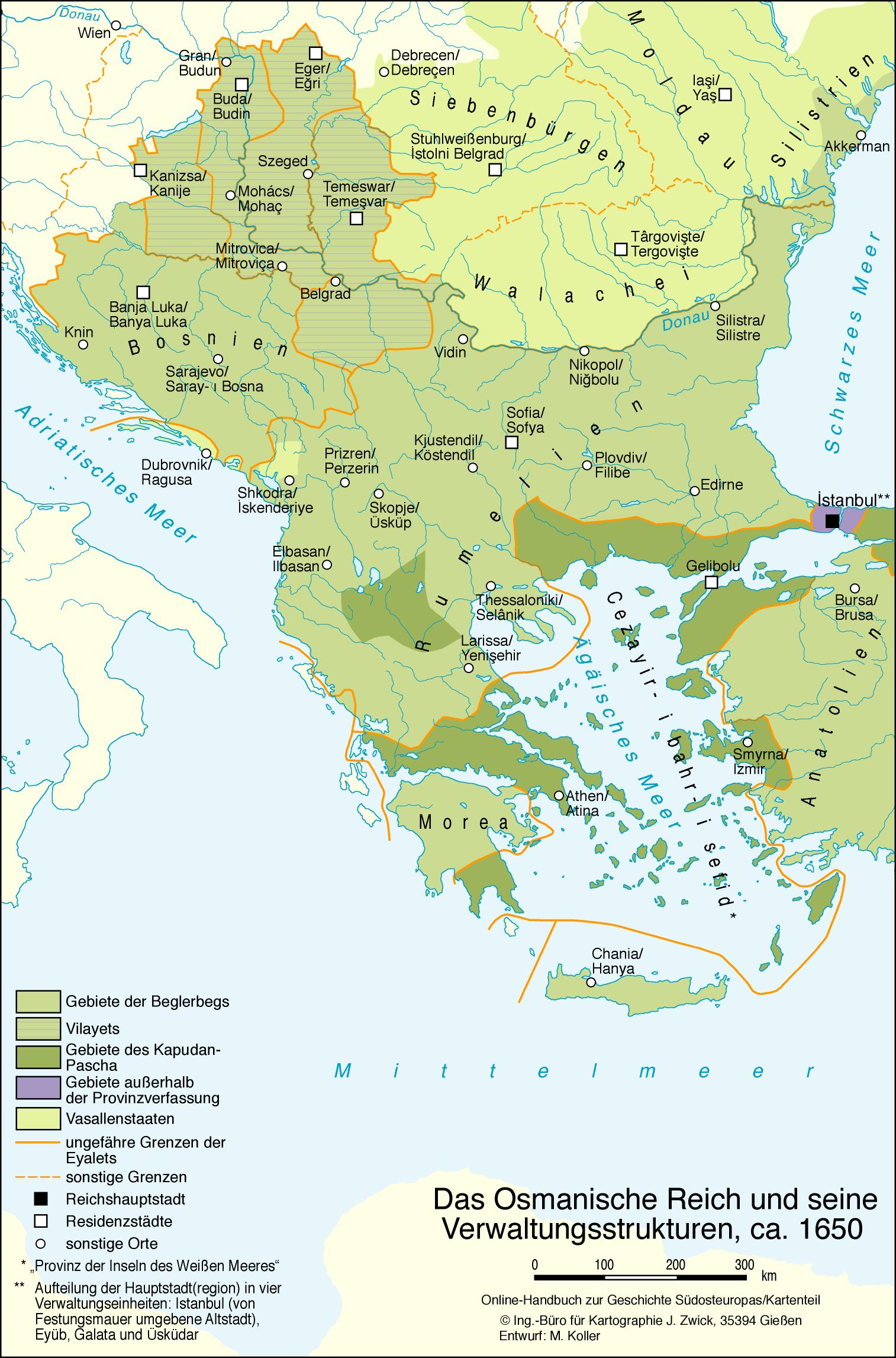
Das Osmanische Reich und seine Verwaltungsstrukturen, ca. 1650:
Saved in:
| Other Authors: | , |
|---|---|
| Format: | Electronic Map Article |
| Language: | German |
| Published: |
[2016]
|
| Subjects: | |
| Online Access: | Volltext |
| Item Description: | Maßstab in graph. Form (Kilometer) |
| Physical Description: | 1 Karte farbig |
Staff View
MARC
| LEADER | 00000nea a2200000 c 4500 | ||
|---|---|---|---|
| 001 | BV049911202 | ||
| 003 | DE-604 | ||
| 005 | 20250326 | ||
| 007 | au||uuun | ||
| 007 | cr|uuu---uuuuu | ||
| 008 | 241017s2016 xx |||||| u o | ger d | ||
| 034 | 0 | |d 14.85 |e 30.85 |f 48.49 |g 30.13 |9 A:dg0 | |
| 035 | |a (DE-599)BVBBV049911202 | ||
| 040 | |a DE-604 |b ger |e rda | ||
| 041 | 0 | |a ger | |
| 049 | |a DE-Re13 | ||
| 245 | 1 | 0 | |a Das Osmanische Reich und seine Verwaltungsstrukturen, ca. 1650 |c Ing.-Büro für Kartographie J. Zwick, 35394 Gießen. - Entwurf: M. Koller |
| 264 | 1 | |c [2016] | |
| 300 | |a 1 Karte |b farbig | ||
| 336 | |b cri |2 rdacontent | ||
| 337 | |b c |2 rdamedia | ||
| 338 | |b cr |2 rdacarrier | ||
| 500 | |a Maßstab in graph. Form (Kilometer) | ||
| 648 | 7 | |a Geschichte 1650 |2 gnd |9 rswk-swf | |
| 650 | 0 | 7 | |a Verwaltungsgliederung |0 (DE-588)4300610-3 |2 gnd |9 rswk-swf |
| 650 | 0 | 7 | |a Geschichtskarte |0 (DE-588)4323411-2 |2 gnd |9 rswk-swf |
| 650 | 0 | 7 | |a Verwaltungsgrenze |0 (DE-588)4188127-8 |2 gnd |9 rswk-swf |
| 651 | 7 | |a Osmanisches Reich |0 (DE-588)4075720-1 |2 gnd |9 rswk-swf | |
| 651 | 7 | |a Südosteuropa |0 (DE-588)4058449-5 |2 gnd |9 rswk-swf | |
| 655 | 7 | |0 (DE-588)4029783-4 |a Karte |2 gnd-content | |
| 689 | 0 | 0 | |a Osmanisches Reich |0 (DE-588)4075720-1 |D g |
| 689 | 0 | 1 | |a Verwaltungsgrenze |0 (DE-588)4188127-8 |D s |
| 689 | 0 | 2 | |a Verwaltungsgliederung |0 (DE-588)4300610-3 |D s |
| 689 | 0 | 3 | |a Südosteuropa |0 (DE-588)4058449-5 |D g |
| 689 | 0 | 4 | |a Geschichtskarte |0 (DE-588)4323411-2 |D s |
| 689 | 0 | 5 | |a Geschichte 1650 |A z |
| 689 | 0 | |5 DE-604 | |
| 700 | 1 | |a Zwick, Joachim |4 ctg | |
| 700 | 1 | |a Koller, Markus |d 1972- |0 (DE-588)140253262 |4 ctb | |
| 773 | 1 | 8 | |g volume:Kartenteil. Karten |g Kultur, Wirtschaft und Gesellschaft |
| 773 | 0 | 8 | |t Online-Handbuch zur Geschichte Südosteuropas / herausgegeben von Ulf Brunnbauer ; Konrad Clewing ; Oliver J. Schmitt ; Koordination und Redaktion: Edvin Pezo |d Regensburg, [2015-] |g Kultur, Wirtschaft und Gesellschaft |k Online-Handbuch zur Geschichte Südosteuropas |w (DE-604)BV044412694 |
| 856 | 4 | 1 | |q image/jpeg |u https://www.hgsoe.ios-regensburg.de/fileadmin/karten/OsmanischeReichUndVerwaltungsstrukturen_ca1650.jpg |x Verlag |z kostenfrei |3 Volltext |
| 940 | 1 | |q IOSVK | |
| 940 | 1 | |q BSB_NED_20241017 | |
| 941 | |b Kartenteil. Karten |r Kultur, Wirtschaft und Gesellschaft | ||
| 942 | 1 | 1 | |c 351.09 |e 22/bsb |f 09032 |g 561 |
| 942 | 1 | 1 | |c 911 |e 22/bsb |f 09032 |g 561 |
| 943 | 1 | |a oai:aleph.bib-bvb.de:BVB01-035249961 | |
Record in the Search Index
| _version_ | 1827646652514566145 |
|---|---|
| adam_text | |
| any_adam_object | |
| article_link | (DE-604)BV044412694 |
| author2 | Zwick, Joachim Koller, Markus 1972- |
| author2_role | ctg ctb |
| author2_variant | j z jz m k mk |
| author_GND | (DE-588)140253262 |
| author_facet | Zwick, Joachim Koller, Markus 1972- |
| building | Verbundindex |
| bvnumber | BV049911202 |
| collection | ebook |
| ctrlnum | (DE-599)BVBBV049911202 |
| era | Geschichte 1650 gnd |
| era_facet | Geschichte 1650 |
| format | Electronic Map Article |
| fullrecord | <?xml version="1.0" encoding="UTF-8"?><collection xmlns="http://www.loc.gov/MARC21/slim"><record><leader>00000nea a2200000 c 4500</leader><controlfield tag="001">BV049911202</controlfield><controlfield tag="003">DE-604</controlfield><controlfield tag="005">20250326</controlfield><controlfield tag="007">au||uuun</controlfield><controlfield tag="007">cr|uuu---uuuuu</controlfield><controlfield tag="008">241017s2016 xx |||||| u o | ger d</controlfield><datafield tag="034" ind1="0" ind2=" "><subfield code="d">14.85</subfield><subfield code="e">30.85</subfield><subfield code="f">48.49</subfield><subfield code="g">30.13</subfield><subfield code="9">A:dg0</subfield></datafield><datafield tag="035" ind1=" " ind2=" "><subfield code="a">(DE-599)BVBBV049911202</subfield></datafield><datafield tag="040" ind1=" " ind2=" "><subfield code="a">DE-604</subfield><subfield code="b">ger</subfield><subfield code="e">rda</subfield></datafield><datafield tag="041" ind1="0" ind2=" "><subfield code="a">ger</subfield></datafield><datafield tag="049" ind1=" " ind2=" "><subfield code="a">DE-Re13</subfield></datafield><datafield tag="245" ind1="1" ind2="0"><subfield code="a">Das Osmanische Reich und seine Verwaltungsstrukturen, ca. 1650</subfield><subfield code="c">Ing.-Büro für Kartographie J. Zwick, 35394 Gießen. - Entwurf: M. Koller</subfield></datafield><datafield tag="264" ind1=" " ind2="1"><subfield code="c">[2016]</subfield></datafield><datafield tag="300" ind1=" " ind2=" "><subfield code="a">1 Karte</subfield><subfield code="b">farbig</subfield></datafield><datafield tag="336" ind1=" " ind2=" "><subfield code="b">cri</subfield><subfield code="2">rdacontent</subfield></datafield><datafield tag="337" ind1=" " ind2=" "><subfield code="b">c</subfield><subfield code="2">rdamedia</subfield></datafield><datafield tag="338" ind1=" " ind2=" "><subfield code="b">cr</subfield><subfield code="2">rdacarrier</subfield></datafield><datafield tag="500" ind1=" " ind2=" "><subfield code="a">Maßstab in graph. Form (Kilometer)</subfield></datafield><datafield tag="648" ind1=" " ind2="7"><subfield code="a">Geschichte 1650</subfield><subfield code="2">gnd</subfield><subfield code="9">rswk-swf</subfield></datafield><datafield tag="650" ind1="0" ind2="7"><subfield code="a">Verwaltungsgliederung</subfield><subfield code="0">(DE-588)4300610-3</subfield><subfield code="2">gnd</subfield><subfield code="9">rswk-swf</subfield></datafield><datafield tag="650" ind1="0" ind2="7"><subfield code="a">Geschichtskarte</subfield><subfield code="0">(DE-588)4323411-2</subfield><subfield code="2">gnd</subfield><subfield code="9">rswk-swf</subfield></datafield><datafield tag="650" ind1="0" ind2="7"><subfield code="a">Verwaltungsgrenze</subfield><subfield code="0">(DE-588)4188127-8</subfield><subfield code="2">gnd</subfield><subfield code="9">rswk-swf</subfield></datafield><datafield tag="651" ind1=" " ind2="7"><subfield code="a">Osmanisches Reich</subfield><subfield code="0">(DE-588)4075720-1</subfield><subfield code="2">gnd</subfield><subfield code="9">rswk-swf</subfield></datafield><datafield tag="651" ind1=" " ind2="7"><subfield code="a">Südosteuropa</subfield><subfield code="0">(DE-588)4058449-5</subfield><subfield code="2">gnd</subfield><subfield code="9">rswk-swf</subfield></datafield><datafield tag="655" ind1=" " ind2="7"><subfield code="0">(DE-588)4029783-4</subfield><subfield code="a">Karte</subfield><subfield code="2">gnd-content</subfield></datafield><datafield tag="689" ind1="0" ind2="0"><subfield code="a">Osmanisches Reich</subfield><subfield code="0">(DE-588)4075720-1</subfield><subfield code="D">g</subfield></datafield><datafield tag="689" ind1="0" ind2="1"><subfield code="a">Verwaltungsgrenze</subfield><subfield code="0">(DE-588)4188127-8</subfield><subfield code="D">s</subfield></datafield><datafield tag="689" ind1="0" ind2="2"><subfield code="a">Verwaltungsgliederung</subfield><subfield code="0">(DE-588)4300610-3</subfield><subfield code="D">s</subfield></datafield><datafield tag="689" ind1="0" ind2="3"><subfield code="a">Südosteuropa</subfield><subfield code="0">(DE-588)4058449-5</subfield><subfield code="D">g</subfield></datafield><datafield tag="689" ind1="0" ind2="4"><subfield code="a">Geschichtskarte</subfield><subfield code="0">(DE-588)4323411-2</subfield><subfield code="D">s</subfield></datafield><datafield tag="689" ind1="0" ind2="5"><subfield code="a">Geschichte 1650</subfield><subfield code="A">z</subfield></datafield><datafield tag="689" ind1="0" ind2=" "><subfield code="5">DE-604</subfield></datafield><datafield tag="700" ind1="1" ind2=" "><subfield code="a">Zwick, Joachim</subfield><subfield code="4">ctg</subfield></datafield><datafield tag="700" ind1="1" ind2=" "><subfield code="a">Koller, Markus</subfield><subfield code="d">1972-</subfield><subfield code="0">(DE-588)140253262</subfield><subfield code="4">ctb</subfield></datafield><datafield tag="773" ind1="1" ind2="8"><subfield code="g">volume:Kartenteil. Karten</subfield><subfield code="g">Kultur, Wirtschaft und Gesellschaft</subfield></datafield><datafield tag="773" ind1="0" ind2="8"><subfield code="t">Online-Handbuch zur Geschichte Südosteuropas / herausgegeben von Ulf Brunnbauer ; Konrad Clewing ; Oliver J. Schmitt ; Koordination und Redaktion: Edvin Pezo</subfield><subfield code="d">Regensburg, [2015-]</subfield><subfield code="g">Kultur, Wirtschaft und Gesellschaft</subfield><subfield code="k">Online-Handbuch zur Geschichte Südosteuropas</subfield><subfield code="w">(DE-604)BV044412694</subfield></datafield><datafield tag="856" ind1="4" ind2="1"><subfield code="q">image/jpeg</subfield><subfield code="u">https://www.hgsoe.ios-regensburg.de/fileadmin/karten/OsmanischeReichUndVerwaltungsstrukturen_ca1650.jpg</subfield><subfield code="x">Verlag</subfield><subfield code="z">kostenfrei</subfield><subfield code="3">Volltext</subfield></datafield><datafield tag="940" ind1="1" ind2=" "><subfield code="q">IOSVK</subfield></datafield><datafield tag="940" ind1="1" ind2=" "><subfield code="q">BSB_NED_20241017</subfield></datafield><datafield tag="941" ind1=" " ind2=" "><subfield code="b">Kartenteil. Karten</subfield><subfield code="r">Kultur, Wirtschaft und Gesellschaft</subfield></datafield><datafield tag="942" ind1="1" ind2="1"><subfield code="c">351.09</subfield><subfield code="e">22/bsb</subfield><subfield code="f">09032</subfield><subfield code="g">561</subfield></datafield><datafield tag="942" ind1="1" ind2="1"><subfield code="c">911</subfield><subfield code="e">22/bsb</subfield><subfield code="f">09032</subfield><subfield code="g">561</subfield></datafield><datafield tag="943" ind1="1" ind2=" "><subfield code="a">oai:aleph.bib-bvb.de:BVB01-035249961</subfield></datafield></record></collection> |
| genre | (DE-588)4029783-4 Karte gnd-content |
| genre_facet | Karte |
| geographic | Osmanisches Reich (DE-588)4075720-1 gnd Südosteuropa (DE-588)4058449-5 gnd |
| geographic_facet | Osmanisches Reich Südosteuropa |
| id | DE-604.BV049911202 |
| illustrated | Not Illustrated |
| indexdate | 2025-03-26T09:01:11Z |
| institution | BVB |
| language | German |
| oai_aleph_id | oai:aleph.bib-bvb.de:BVB01-035249961 |
| open_access_boolean | 1 |
| owner | DE-Re13 DE-BY-UBR |
| owner_facet | DE-Re13 DE-BY-UBR |
| physical | 1 Karte farbig |
| psigel | IOSVK BSB_NED_20241017 |
| publishDate | 2016 |
| publishDateSearch | 2016 |
| publishDateSort | 2016 |
| record_format | marc |
| spelling | Das Osmanische Reich und seine Verwaltungsstrukturen, ca. 1650 Ing.-Büro für Kartographie J. Zwick, 35394 Gießen. - Entwurf: M. Koller [2016] 1 Karte farbig cri rdacontent c rdamedia cr rdacarrier Maßstab in graph. Form (Kilometer) Geschichte 1650 gnd rswk-swf Verwaltungsgliederung (DE-588)4300610-3 gnd rswk-swf Geschichtskarte (DE-588)4323411-2 gnd rswk-swf Verwaltungsgrenze (DE-588)4188127-8 gnd rswk-swf Osmanisches Reich (DE-588)4075720-1 gnd rswk-swf Südosteuropa (DE-588)4058449-5 gnd rswk-swf (DE-588)4029783-4 Karte gnd-content Osmanisches Reich (DE-588)4075720-1 g Verwaltungsgrenze (DE-588)4188127-8 s Verwaltungsgliederung (DE-588)4300610-3 s Südosteuropa (DE-588)4058449-5 g Geschichtskarte (DE-588)4323411-2 s Geschichte 1650 z DE-604 Zwick, Joachim ctg Koller, Markus 1972- (DE-588)140253262 ctb volume:Kartenteil. Karten Kultur, Wirtschaft und Gesellschaft Online-Handbuch zur Geschichte Südosteuropas / herausgegeben von Ulf Brunnbauer ; Konrad Clewing ; Oliver J. Schmitt ; Koordination und Redaktion: Edvin Pezo Regensburg, [2015-] Kultur, Wirtschaft und Gesellschaft Online-Handbuch zur Geschichte Südosteuropas (DE-604)BV044412694 image/jpeg https://www.hgsoe.ios-regensburg.de/fileadmin/karten/OsmanischeReichUndVerwaltungsstrukturen_ca1650.jpg Verlag kostenfrei Volltext |
| spellingShingle | Das Osmanische Reich und seine Verwaltungsstrukturen, ca. 1650 Verwaltungsgliederung (DE-588)4300610-3 gnd Geschichtskarte (DE-588)4323411-2 gnd Verwaltungsgrenze (DE-588)4188127-8 gnd |
| subject_GND | (DE-588)4300610-3 (DE-588)4323411-2 (DE-588)4188127-8 (DE-588)4075720-1 (DE-588)4058449-5 (DE-588)4029783-4 |
| title | Das Osmanische Reich und seine Verwaltungsstrukturen, ca. 1650 |
| title_auth | Das Osmanische Reich und seine Verwaltungsstrukturen, ca. 1650 |
| title_exact_search | Das Osmanische Reich und seine Verwaltungsstrukturen, ca. 1650 |
| title_full | Das Osmanische Reich und seine Verwaltungsstrukturen, ca. 1650 Ing.-Büro für Kartographie J. Zwick, 35394 Gießen. - Entwurf: M. Koller |
| title_fullStr | Das Osmanische Reich und seine Verwaltungsstrukturen, ca. 1650 Ing.-Büro für Kartographie J. Zwick, 35394 Gießen. - Entwurf: M. Koller |
| title_full_unstemmed | Das Osmanische Reich und seine Verwaltungsstrukturen, ca. 1650 Ing.-Büro für Kartographie J. Zwick, 35394 Gießen. - Entwurf: M. Koller |
| title_short | Das Osmanische Reich und seine Verwaltungsstrukturen, ca. 1650 |
| title_sort | das osmanische reich und seine verwaltungsstrukturen ca 1650 |
| topic | Verwaltungsgliederung (DE-588)4300610-3 gnd Geschichtskarte (DE-588)4323411-2 gnd Verwaltungsgrenze (DE-588)4188127-8 gnd |
| topic_facet | Verwaltungsgliederung Geschichtskarte Verwaltungsgrenze Osmanisches Reich Südosteuropa Karte |
| url | https://www.hgsoe.ios-regensburg.de/fileadmin/karten/OsmanischeReichUndVerwaltungsstrukturen_ca1650.jpg |
| work_keys_str_mv | AT zwickjoachim dasosmanischereichundseineverwaltungsstrukturenca1650 AT kollermarkus dasosmanischereichundseineverwaltungsstrukturenca1650 |